Official Destination Website
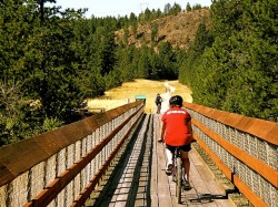
This hike includes crossing the Kettle River downstream of the falls on a 505 foot trestle bridge (Kettle River Bridge #5, now the Smitten Trestle), one of the longest on the Canadian Pacific Railway, which was redecked in 2004 as a joint military exercise with the CME and British and New Zealand troops. While approaching the bridge, the townsite of Cascade is to your north.
To access this section, take the 395 turnoff and head south. You’ll see a yellow service building to the west where the Trans Canada Trail crosses the highway, and a small parking area to the left (east) at the trail entrance. The bridge is an easy 15 minute hike along the old railway grade. Towering above the river basin below, the view from the bridge is stunning!
The trail continues on around the valley, making its way up to Santa Rosa, with plenty of scenic vistas along the way.
Santa Rosa to Kettle River Trestle Bridge
This stretch will take you down a gentle decline on a scenic tour of the valley overlooking the Kettle River and farmlands as you wind around and down to the long trestle bridge. The first viewpoint is about a 5 minute walk, where Christina Creek joins the Kettle River, with the highway bridge in the distance. Further on, the long trestle comes into view across the fields. Great for a quick hike or bike ride.
Turn off Highway #3 and follow Santa Rosa 1.5 km until immediately before you reach the first switchback, and look for the parking area and information kiosk to your left. Cross Santa Rosa and follow the path marked by the yellow trailhead sign.