
Official Destination Website
We are excited to share our beautiful trails and backcountry with you, one step at a time!
Snowshoes can be picked up and dropped off by users at the Visitor Centre kiosk at 1675 Hwy 3 Rental equipment may be transported to other locations within the region.
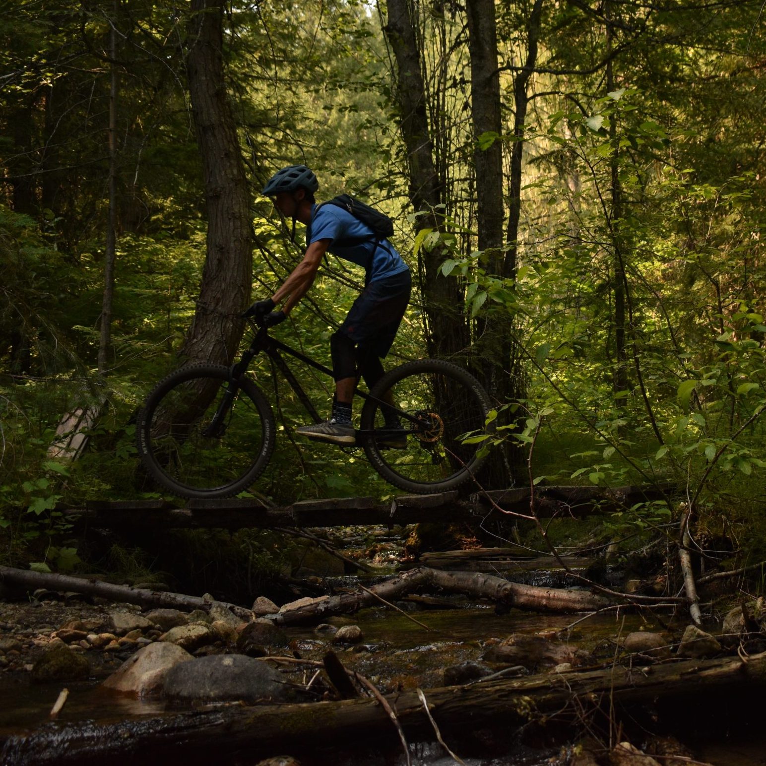
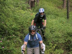
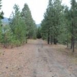
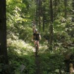
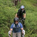
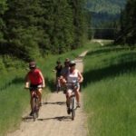
The outdoorsy culture here at Christina lake grows more and more each year with new trails being made by the locals, old trails being rediscovered, and growing community events around biking as a whole.
We are positive there is a trail for everybody here at The Lake, as well as that there is no reason to be bored here with endless opportunities all around our small community!
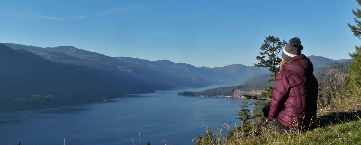
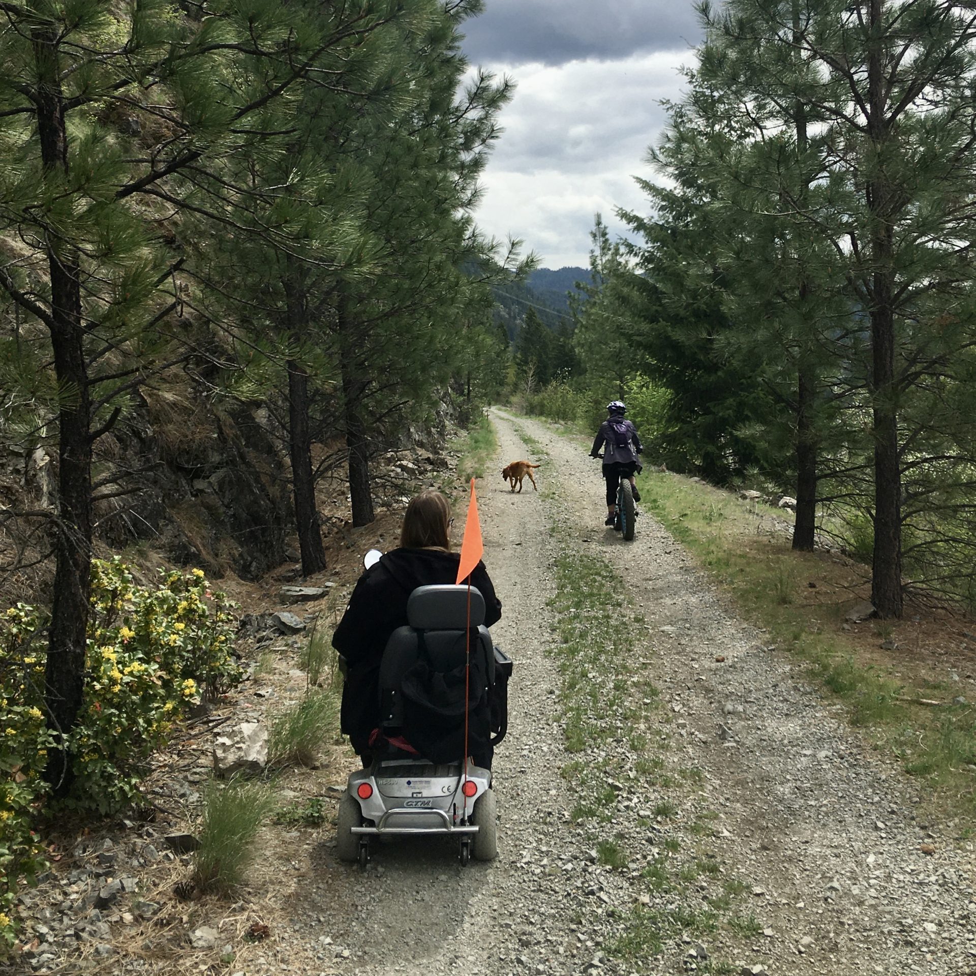
Our Christina Lake Provincial Park has recently become one of few BC Parks with access to a Mobi-Mat, a specialized floating chair, and accessible parking spaces. These features are wonderful additions for those who require them, but also are intended to be a reflection of the community’s strength when we work together. The lake is for everybody, and the reminder these features serve of this is among their best qualities. Happy trails, everyone!
A 92 foot long Mobi-Mat is made of a tough material that allows wheelchair access to the water. the mat is set up at the far left of the beach and is out between May and September depending on water levels.
The most recent addition to our accessibility options, the floating chair is available for anyone who has a support person with them. A waiver is issued at the Christina Lake Welcome Center through Tourism, who will also assist on site at the park to unlock and set up the chair. A life jacket can be provided and is mandatory for use. To ensure regulation and security of the equipment, we ask that a card is left with Tourism as collateral, which will be returned once the chair is put away.
Designated accessibility parking is available near the washrooms/change rooms for better access to the lake.
There are two staging areas for the Trans Canada which are the most ideal for accessibility parking, making it easier to enjoy the popular Christina Lake sights along the trail.
Across the highway from the Welcome Center is Santa Rosa road. The staging area is located up the mountain, just before the pavement ends on the left hand side. This section of the trail brings you to a lookout over the Lake, and is available for all to enjoy! You can get the directions here.
Following the 395 just past the Cascade Falls will lead you to the staging area that brings you closest to the grand trestle bridge. Its a view perfect for an evening walk, which you can find here.
For further reading on accessibility at Christina Lake visit: BC Parks Blog
This trail offers moderate biking and an easy hike. There are some great viewpoints overlooking the Kettle Valley and south into the USA. This historical trail is over 150 years old, being the original horse pack route through the region.
Distance: 4.6 km plus 2.3 km road in from Santa Rosa
Difficulty:
Hike: Easy
Bike: Moderate/Difficult
Elev. Change: 480 m
Uses: Hiking, Mountain Biking, Horseback Riding
Trail Head Access :
Take Santa Rosa Road off of Highway #3 and follow it for 24 km, reaching the parking area for the Christina Crest Trail. From there, take the middle road as it winds down and around right to the height of land. Follow until the road meets the gas line and a small parking area with a great view west. Hikers may prefer to access the trail at the 14 km point on Santa Rosa Rd. and ascend to the summit.

A technical single-track that follows along the creek and joins a fire access road. Use this trail as the start to the Deer Point/ Troy Creek trail. An easy and scenic hike.
Distance : 2 km
Difficulty : Hike: Easy
Bike: Moderate
Time : Hike: 30 min
Uses : Hiking & Biking
Trail Head Access :
Take Highway #3 to the East Lake Drive turn off and follow until you come to the bridge, park in the area immediately past. Look for a trail on the north side of the creek. Follow the trail to the footbridge over Texas Point, turn left to the junction of the Deer Point and Mt. Gladstone trails or explore some of the many deer trails that transect the area.
This stretch gives you the same panoramic views as the previous, with the entrance off Fife Road. After a short walk though the trees, the trail opens to a gully where Sutherland creek flows beneath. At a moderate pace, the first viewpoint is roughly twenty-five minutes in with two more vantage points not much further on. From here you can see the south end of the lake and Christina Lake village, and well up the highway to the south. Bring your camera!
Drive up Fife Road to the Trans Canada Trail crossing, which you’ll find just around the bend from an old log barn, and land marked by the original Fife station building to your left. Enter the trail through the gates to the right (south).
Nestled in the south east corner of the lake just off Highway #3, our Community Nature Park offers year round sanctuary. It is the perfect place to take a quiet stroll with the family, a short bike ride, or enjoy an leisurely summer afternoon with a picnic. Fall brings a festival of colors with the autumn foliage while in winter months, the park is ideal for easy snowshoeing or cross country skiing. Picnic tables are situated throughout the park, allowing a reprieve with views of the lake.
The park provides a variety of sights along its collection of trails, named after the many birds found in the area. Explore the scenic shoreline along Sandpiper, the meadows of Kildeer and Towhee, or the wooded areas of Kingfisher or Woodpecker. Take a walk along Eagle Trail where Sutherland Creek has been refurbished to encourage kokanee spawning with plantings along its banks to provide shade and purposefully placed logs to create spawning beds. Watch closely and you may spot a turtle or two sunning on the logs at the mouth of the creek. Blue Heron trail follows Christina Creek where you will find a large and very active beaver lodge.
The trails in the park reveal abundant bird life, whitetail deer, rabbits, squirrels, and even a giant anthill or two. You will see assorted ducks, otter at play, beaver if you’re quick, heron if you’re quiet, and the very familiar Canada geese. Please obey the leash bylaws while in our park. The wildlife is not for “fido” to chase.
The result of 15 years of community support and effort has realized our vision of a Community Park with walking trails, a visitor and art centre and much more. The new Christina Lake Living Arts Centre is home to the Chamber of Commerce, the tourist info centre, and the Christina Lake Stewardship offices. There is also a coffee and gift shop, Living Machine Waste water treatment plant and studio space for the Christina Lake Arts and Artisans Society including a hot shop for glass blowing.
Deer Point & Troy Creek Trail
Description :
A beautiful trail to the head of the lake where huge cedar trees and a sandy beach await you. The trail starts out steep but levels off and rolls gently up and down along the shoreline to Deer Point.
Distance : 10 km (one way)
Difficulty : Hike: Moderate
Bike: Moderate-Difficult
(Some narrow sections with drop-offs)
Time : Hike: 6 hours to the lake head
Bike: 2 1/2 hours to lake head
Ascent : 200 m.
Uses : Hiking & Biking
Trail Head Access :
The trailhead is located between the boat parking area, off East Lake Drive and the provincial campground at Texas Creek. Signs and a comments box mark the trailhead at the rear of the parking area.
At 8km take the Troy Creek trail to get to the head of the lake or descend to Deer Point camping area on the lake.
Click here for a map of the Christina Lake Community Nature park.
This is one of the few trails in this region located in an alpine setting. It follows the ridge line from the Santa Rosa summit to Mt. St. Thomas and is a multi-day hike or a long day biking. Be prepared for a rugged backcountry experience and bring water as none is available along route. This trail boasts alpine meadows and rock bluffs with panoramic views in all directions, including spectacular views of Christina Lake and Big Sheep Creek valleys. It often has windfall and is remote. The trail can have snow on it well into July. Check with WildWays for trail conditions.
For a day trip, pack a lunch and enjoy a pleasant hike about an hour’s trek to the first meadow, allowing a spectacular view over multiple mountain ranges the south. The trail follows a moderate grade uphill and is a bit scrambly in places due to loose material, but fairly easy. The Santa Rosa drive has many scenic spots looking out over the Kettle River and valleys along the way.
Starts at 1620 m elevation to max height of 2080 m. Various ups and downs in between.
Distance: 14.6 km to top of Mt. St Thomas
Difficulty: Hike: Moderate – Difficult (remote)
Bike: Difficult
Time: Hike: 2 days
Bike: a long day
Snowshoeing/Ski-touring (2 days)
Elev. Change: 550 m
Uses: Hiking, Mountain Biking, Horseback Riding, Snowshoeing, Skiing
Trail Head Access :
Follow Santa Rosa Road (off of Highway #3) 24 km to parking area across from the trailhead. The trail leads along the height of land and there are some good camping spots along the way. Once at Mt. St. Thomas (16 km) take the left fork to descend via Vertical Smile trail to Fife Road or go right and descend a short steep trail leading to Bonanza Creek FSR, which takes you to Highway #3. Be aware that Santa Rosa is an active logging area, so be prepared to yield to logging trucks. Four wheel drive vehicles are recommended.
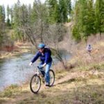
This trail follows along the shores of Christina Creek, the only outflow of Christina Lake. It covers a short distance making it accessible to most ages and abilities. In places the trail dips down offering access to sandbars and pools along the creek. There is ample opportunity to view the abundant wildlife. Keep an eye out for beavers, muskrats, and a large variety of birds. Watch for poison ivy along the creek.
Distance: 2 km
Difficulty: Hike: Easy – Moderate
Suitable for almost all ages and abilities
Time: Hike: 45 minutes
Elev. Change: 55 m
Uses: Hiking, Mountain Biking, Swimming, Fishing, Horseback Riding
Trail Head Access :
Just north of the Highway #3 Bridge over Christina Creek there is a turn off to the right and a small parking area. Follow on foot for 50 m, the trail dips down to the right. At km 1.5 the trail climbs the bank and then turns left, avoiding private property at the fenced section. Go downhill for .7 km and look for a small road on the left leading gently downhill. Follow this road and look for a trail on your right. This trail joins another small road leading back to the parking area.
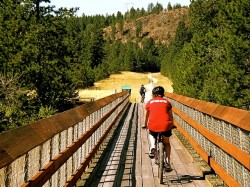
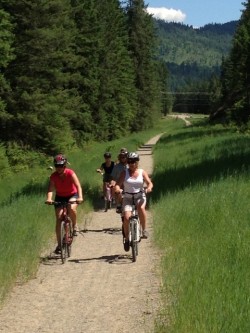
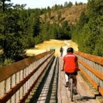
Ideal for a family hike or bike, the old Kettle Valley Railway was decommissioned several years ago and is now part of the Trans Canada Trail. The Cascade Gorge area offers a great variety of sights and viewpoints, and is one of the most popular areas to explore around the lake. Along with the spectacular natural scenery to be found as the Kettle River carves its way through the rocky Gorge Canyon, there are also remnants of the Cascade power project, which produced some of the first AC current in the region, and opened the surrounding region to electrical power.
The trip from Santa Rosa down to Highway #3 follows the old Kettle Valley Railway bed and includes the crossing the Kettle River and Cascade Gorge on two CPR tressel bridges which have been redecked with guard rails installed. For shorter trips and more exploring options of this area, see the Trans Canada Trail page.
Distance: 5 km
Difficulty: Hike: Easy
Bike: Easy
Time: Hike: 1/2 Day
Uses: Hiking & Biking
Trail Head Access :
Follow Santa Rosa Road off of Highway #3 until just before you reach the first switchback (1.5km) and a parking area to your left. The trail is accessed by crossing Santa Rosa Road. and following the gravel track around the switchback. From here the trail slopes gently down towards the first trestle. After this, follow the rail grade, crossing Highway #395. The Falls may be accessed by crossing over a small concrete bridge (the bulkhead) just off the trail on the right, and following the path. There are no guardrails or fencing; use extreme caution while viewing from the rock cliffs. Once over the second trestle there is a short road to the right leading up to Highway #3. To return to Christina Lake, turn right and follow the highway until you reach Thompson Road (on the left). Follow Thompson Road. back down to Westlake Drive, turn right and follow to Highway #3.
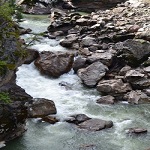
Carved over millions of years as the Kettle River scoured through its metamorphic rock, the Cascade Gorge is one of our most treasured natural attractions. In the spring, the winter melt off surges through the canyon with an awesome display of power; by the end of summer the water levels recede to reveal the series of “kettles” carved in to the canyon walls and basin. A “must see” attraction while in the region, it must be experienced in person to be fully appreciated.
The gorge is also the site of the region’s first AC power generating station. The Cascade Dam dam at the head of the gorge diverted the Kettle River through a 125 m tunnel bored through solid rock into a man-made rock cut where the water entered a pair of 2 m diameter wooden stave pipes 500 m in length before reaching the power station at the foot of the gorge. The remains of this monumental undertaking can still be found, with the concrete bulkhead now forming a foot bridge to the viewing areas. For more information on the Cascade Dam visit the virtual museum website.
Exercise extreme caution while exploring this area, as the rocks can be slippery, and there are no guardrails or fencing. Enjoy the views from a safe distance.
There are two primary access points to the gorge section.
Gorge Canyon Trestle Bridge to Cascade Falls
Heading west from Christina Lake on Highway #3, pull into the turnout on your left just past the 395 junction where the welcome sign is located. Here you will find the short descent to the Trans Canada Trail. Once you reach the main trail, to your right is the bridge, which offers some great photo opportunities of the Kettle River winding underneath through the narrow rock fissure. To the south of the bridge is where the Cascade Dam stood from1898 to 1922.
Following the railway bed, after about a five minute walk you will find the top of the old concrete bulkhead off to your left. After crossing the bulkhead, follow the path to your right which will lead you out to the cliff face for a spectacular view of the gorge and falls.
Cascade Falls to penstock trail
After leaving Christina Lake, follow Highway #3 and take the Highway #395 turnoff. Immediately after crossing the bridge, pull off to your right where you will find a fairly steep staircase taking you up to the falls trail. This hike offers a couple of options;
To get to the closest vantage point for the falls, take the path leading off the main trail to your right, which will get you to the east bluff and Rainbow Rock. From here, you can follow a trail skirting the gorge to other view points.
Continuing on the main trail will take you to into a rock cut to the base of the old control gate bulkhead and into the penstock, past the ruins of the spillways and further on to the entrance of what is now a giant cave, originally the tunnel through which water was diverted from the river into the penstock.
You can also get to the west side of the gorge by turning right before you arrive at the bulkhead. Access to the railway grade is by crossing the bulkhead and climbing a short embankment. Turning to your right (west) will take you to the gorge trestle bridge and back to Highway #3. Following the rail bed to your left (east) will bring you to Highway #395, and on to the long trestle bridge
This short trail connects McRae Creek Road to Biner Road, which is the trailhead of the Deer Point Trail. A moderate hiking trail with frequent views of Christina Lake. Suitable for most ability levels, though those with bad knees may want to avoid the section with rocky steps at the McCrae Creek end of the trail.
Badger provides an intermediate singletrack biking trail with a few rocky sections and steep descents. Riders should carry their bikes up the steep rocky section from McRae Creek Road and enjoy the moderate downhill ride along the mountainside to Biner Road and Deer Point trailhead. Be sure to bring water as none is available along the trail.
Distance: 2.2 km
Difficulty: Hike: Easy – Moderate
Bike: Intermediate (singletrack)
Elev. Change: 110 m
Uses: Hiking & Mountain Biking
Trail Head Access :
Lower end (hiking): From the bridge on Highway #3, head northeast for 7.3 km to the junction of East Lake Drive. Turn left, follow for 3.6 km keeping to the left after the bridge to Biner Road on the right, where the trailhead sign is located. This private road is the start of the trail. Park at the side of the road, clear of local traffic. An unpainted sign marks the trail head about 0.5 km along Biner Road.
Upper end: Take Highway #3 past the East Lake Drive turnoff and up around the bend where McRae Creek Road meets the highway on the left. Follow 1.3 km until you reach a sharp left turn where is a small parking area and some barricades. Follow past the barricades about 50 m to the steep trailhead; after scrambling up the first rocky section you can follow Badger Trail by keeping to the left, or the more difficult Mary’s Lookout Trail which climbs to the right a little ways in.
To access the McRae Creek entrance from East Lake Drive Drive, look for McRae Road to your right immediately after the bridge, 2.2 km from the highway. Follow McRae for 1.3 km to a steep right turn in the road where the original straight ahead section of road has been blocked.
In for the ride of your season? Check out Spooner Creek Trail. This trail is a classic single-track mountain bike trail providing some climbing, steep descents, technical sections, and optional stunts. It provides great viewpoints looking east over Christina Lake.
Distance : 4.25 km
Difficulty : Hike: Moderate – Difficult
Bike: Difficult
Time : Hike: 1 – 3 hours
Descent : 550m
Uses : Hiking & Mountain Biking
Trail Head Access :
Follow Highway #3 west towards Grand Forks. Just after the Highway #395, turn right onto Stewart Creek Rd. Follow for 9.6 km where there is a small pullout and the trailhead for Spooner Creek Trail. The trail descends from here down to West Lake Dr.
This hike includes crossing the Kettle River downstream of the falls on a 505 foot trestle bridge (Kettle River Bridge #5, now the Smitten Trestle), one of the longest on the Canadian Pacific Railway, which was redecked in 2004 as a joint military exercise with the CME and British and New Zealand troops. While approaching the bridge, the townsite of Cascade is to your north.
To access this section, take the 395 turnoff and head south. You’ll see a yellow service building to the west where the Trans Canada Trail crosses the highway, and a small parking area to the left (east) at the trail entrance. The bridge is an easy 15 minute hike along the old railway grade. Towering above the river basin below, the view from the bridge is stunning!
The trail continues on around the valley, making its way up to Santa Rosa, with plenty of scenic vistas along the way.
Santa Rosa to Kettle River Trestle Bridge
This stretch will take you down a gentle decline on a scenic tour of the valley overlooking the Kettle River and farmlands as you wind around and down to the long trestle bridge. The first viewpoint is about a 5 minute walk, where Christina Creek joins the Kettle River, with the highway bridge in the distance. Further on, the long trestle comes into view across the fields. Great for a quick hike or bike ride.
Turn off Highway #3 and follow Santa Rosa 1.5 km until immediately before you reach the first switchback, and look for the parking area and information kiosk to your left. Cross Santa Rosa and follow the path marked by the yellow trailhead sign.
This former logging road was de-activated many years ago and now provides an easy hiking/biking trail that leads from Santa Rosa Rd. to Fife Rd. There are some great viewpoints along the trail of the Christina Lake valley, Grand Forks and Laurier as it follows through a 2nd growth forest, abundant with wildlife. The trail rises 340m from Santa Rosa to the summit, then falls 590m to Hagluund Rd.
Distance : 10.7 km plus 1.2 km in from Santa Rosa
Difficulty : Moderate – Difficult
Time : 1.5 hour bike ride
Uses : Hiking, Biking, Horseback Riding
Trail Head Access :
Access: Green Tunnel Trail is best accessed from Maida Creek FSR, 7km up Santa Rosa Road. Follow Maida Creek FSR for 2 km reaching the trailhead. Just past the Dewdney Trailhead there is a parking area and the beginning of the Green Tunnel.
The trail comes out on Hagluund Road. Take that down to Fife, which then takes you back to Christina Lake.
he region’s newest Provincial Park offers a level grade through the wide open grasslands and dry forest, for relaxed hiking or bike riding. Established to protect the feeding and critical winter habitat for a large population of whitetailed and mule deer, elk and bighorn sheep, the scenery is panoramic, with the Kettle River flowing to the south and rolling hills to the north. The trail winds its way along the valley, eventually passing the historic town site of Billings, before arriving at the trestle bridge over Cascade Gorge.
There are several entry points to the Trans Canada Trail in and around the Gilpin Grasslands. Head west from Christina Lake along Highway #3 and look for the Trans Canada Trail markers to the south.
Opening in 2000, the Trans Canada Trail is a 21,500-kilometre recreational trail winding its way through every province and territory, from the Atlantic to Pacific to Arctic Oceans. When completed, it will be the world’s longest recreational trail, linking close to 1000 communities and over 33 million Canadians.
Now part of the Spirit of 2010 Trail, the Christina Lake section presents a unique and diverse experience for hikers and bike riders. Explore the open terrain of the Gilpin Grasslands, the awe inspiring natural wonders of the Cascade Gorge and the Kettle River Trestle Bridge to the west. Enjoy spectacular views from the heights of the Santa Rosa/Fife section and the ascent to the Paulson summit along the historic Kettle Valley Railway grade to the northeast. The full journey from Grand Forks to Castlegar will take you across two recently redecked trestle bridges, several rail bridges, through six tunnels, and past numerous historic sites including Cascade Dam, the Fife ore loading tower and Bulldog Tunnel.
With an abundance of access points along the way, travelers can take their time exploring the trail section by section. WildWays offers convenient shuttle services for hikes or biking, and while you are there, be sure to pick up your copy of the new Trans Canada Trail: British Columbia guidebook.
We are excited to share our beautiful trails and backcountry with you, one step at a time! Snowshoes can be picked up and dropped off by users at the Visitor Centre kiosk at 1675 Hwy 3 Rental equipment may be transported to other locations within the region.
We are excited to share our beautiful trails and backcountry with you, one...
The outdoorsy culture here at Christina lake grows more and more each year with new trails being made by the locals, old trails being rediscovered, and growing community events around biking as a whole. We are positive there is a trail for everybody here at The Lake, as well as that there is no reason to be...
The outdoorsy culture here at Christina lake grows more and more each year...
Accessibility at the Christina Lake Provincial Park Our Christina Lake Provincial Park has recently become one of few BC Parks with access to a Mobi-Mat, a specialized floating chair, and accessible parking spaces. These features are wonderful additions for those who require them, but also are intended to be a reflection of the community's strength when we...
Accessibility at the Christina Lake Provincial Park Our Christina Lake Provincial Park has...

This trail offers moderate biking and an easy hike. There are some great viewpoints overlooking the Kettle Valley and south into the USA. This historical trail is over 150 years old, being the original horse pack route through the region. Distance: 4.6 km plus 2.3 km road in from Santa Rosa Difficulty: Hike: Easy Bike: Moderate/Difficult Elev....
This trail offers moderate biking and an easy hike. There are some great...
A technical single-track that follows along the creek and joins a fire access road. Use this trail as the start to the Deer Point/ Troy Creek trail. An easy and scenic hike. Distance : 2 km Difficulty : Hike: Easy Bike: Moderate Time : Hike: 30 min Uses : Hiking & Biking Trail Head Access : Take...
A technical single-track that follows along the creek and joins a fire access...
This stretch gives you the same panoramic views as the previous, with the entrance off Fife Road. After a short walk though the trees, the trail opens to a gully where Sutherland creek flows beneath. At a moderate pace, the first viewpoint is roughly twenty-five minutes in with two more vantage points not much further on. From...
This stretch gives you the same panoramic views as the previous, with the...
Nestled in the south east corner of the lake just off Highway #3, our Community Nature Park offers year round sanctuary. It is the perfect place to take a quiet stroll with the family, a short bike ride, or enjoy an leisurely summer afternoon with a picnic. Fall brings a festival of colors with the autumn foliage...
Nestled in the south east corner of the lake just off Highway #3,...
This is one of the few trails in this region located in an alpine setting. It follows the ridge line from the Santa Rosa summit to Mt. St. Thomas and is a multi-day hike or a long day biking. Be prepared for a rugged backcountry experience and bring water as none is available along route. This trail...
This is one of the few trails in this region located in an...
This trail follows along the shores of Christina Creek, the only outflow of Christina Lake. It covers a short distance making it accessible to most ages and abilities. In places the trail dips down offering access to sandbars and pools along the creek. There is ample opportunity to view the abundant wildlife. Keep an eye out for...
This trail follows along the shores of Christina Creek, the only outflow of...
Ideal for a family hike or bike, the old Kettle Valley Railway was decommissioned several years ago and is now part of the Trans Canada Trail. The Cascade Gorge area offers a great variety of sights and viewpoints, and is one of the most popular areas to explore around the lake. Along with the spectacular natural scenery...
Ideal for a family hike or bike, the old Kettle Valley Railway was...
Carved over millions of years as the Kettle River scoured through its metamorphic rock, the Cascade Gorge is one of our most treasured natural attractions. In the spring, the winter melt off surges through the canyon with an awesome display of power; by the end of summer the water levels recede to reveal the series of "kettles"...
Carved over millions of years as the Kettle River scoured through its metamorphic...
This short trail connects McRae Creek Road to Biner Road, which is the trailhead of the Deer Point Trail. A moderate hiking trail with frequent views of Christina Lake. Suitable for most ability levels, though those with bad knees may want to avoid the section with rocky steps at the McCrae Creek end of the trail. Badger...
This short trail connects McRae Creek Road to Biner Road, which is the...
In for the ride of your season? Check out Spooner Creek Trail. This trail is a classic single-track mountain bike trail providing some climbing, steep descents, technical sections, and optional stunts. It provides great viewpoints looking east over Christina Lake. Distance : 4.25 km Difficulty : Hike: Moderate - Difficult Bike: Difficult Time : Hike: 1 -...
In for the ride of your season? Check out Spooner Creek Trail. This...

This trail is steep in sections and is popular with mountain bikers. It provides a moderate hike leading to some viewpoints of the lake and valley near the top. As a hike it has some steep and loose sections. Distance : 3.5 km, plus 1.2 km in from Santa Rosa Difficulty : Hike: Moderate Bike: Moderate/Difficult Elev....
This trail is steep in sections and is popular with mountain bikers. It...
This hike includes crossing the Kettle River downstream of the falls on a 505 foot trestle bridge (Kettle River Bridge #5, now the Smitten Trestle), one of the longest on the Canadian Pacific Railway, which was redecked in 2004 as a joint military exercise with the CME and British and New Zealand troops. While approaching the bridge,...
This hike includes crossing the Kettle River downstream of the falls on a...
This former logging road was de-activated many years ago and now provides an easy hiking/biking trail that leads from Santa Rosa Rd. to Fife Rd. There are some great viewpoints along the trail of the Christina Lake valley, Grand Forks and Laurier as it follows through a 2nd growth forest, abundant with wildlife. The trail rises 340m...
This former logging road was de-activated many years ago and now provides an...
he region's newest Provincial Park offers a level grade through the wide open grasslands and dry forest, for relaxed hiking or bike riding. Established to protect the feeding and critical winter habitat for a large population of whitetailed and mule deer, elk and bighorn sheep, the scenery is panoramic, with the Kettle River flowing to the south...
he region's newest Provincial Park offers a level grade through the wide open...
This is another classic single-track mountain bike trail with a few steep technical descents. As a hiking trail it is loose and steep in sections but follows along the ridgeline providing spectacular scenic views of Christina Lake to the east and south. The steep up-hill sections and technical descents will keep all types of mountain bikers entertained....
This is another classic single-track mountain bike trail with a few steep technical...
Opening in 2000, the Trans Canada Trail is a 21,500-kilometre recreational trail winding its way through every province and territory, from the Atlantic to Pacific to Arctic Oceans. When completed, it will be the world's longest recreational trail, linking close to 1000 communities and over 33 million Canadians. Now part of the Spirit of 2010 Trail, the...
Opening in 2000, the Trans Canada Trail is a 21,500-kilometre recreational trail winding...
At 25 km for the full trip, this leg of the trail is only for extremely dedicated hikers, as it will take a full day to reach Fife Road, but makes for an excellent half day biking trip. The rewards include passing through Paulson Tunnel, crossing the old Snowslide railway bridge and finally the ore loading tower...
At 25 km for the full trip, this leg of the trail is...